Europe is famous for fast trains, historic underground stations and sprawling urban transit networks. Cities such as London, Paris, Madrid and Moscow move millions of passengers through tunnels every day.
But the map tells a very different story across large parts of the continent.
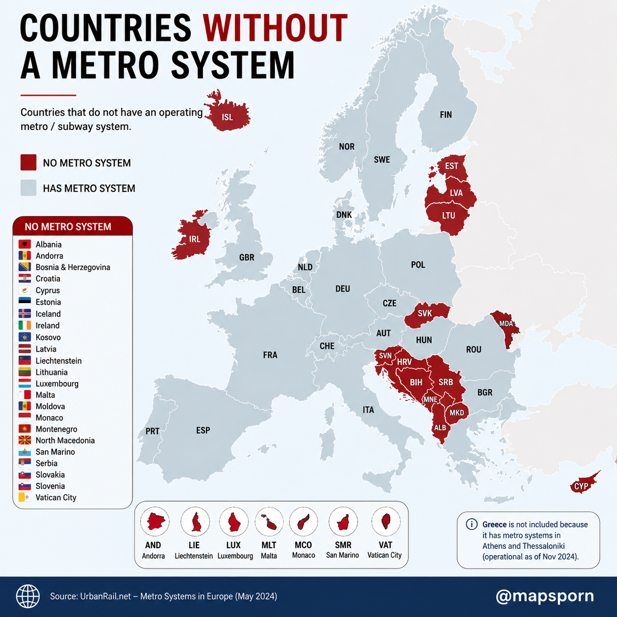
According to the infographic’s stated 2024 cutoff, 23 European countries and microstates did not have an operating metro or subway system. The list includes not only tiny places such as Vatican City and Monaco, but also larger nations such as Ireland, Serbia, Croatia and Bosnia and Herzegovina.
The result is a surprisingly uneven transit map: Western and Central Europe are dominated by countries with metros, while the Balkans and Baltic region contain several notable gaps.
The 23 European Countries Without a Metro
The countries and territories identified on the map are:
Albania, Andorra, Bosnia and Herzegovina, Croatia, Cyprus, Estonia, Iceland, Ireland, Kosovo, Latvia, Liechtenstein, Lithuania, Luxembourg, Malta, Moldova, Monaco, Montenegro, North Macedonia, San Marino, Serbia, Slovakia, Slovenia and Vatican City.
Some of these entries are easy to understand. Vatican City and Monaco are extremely small, while Andorra, Liechtenstein and San Marino have populations far below those of a typical major European city.
Others are much more surprising.
Ireland May Be the Biggest Surprise
Ireland stands out as one of the wealthiest and more populous countries on the map without an operating metro system.
Dublin is a major European capital with a large commuter population, yet it has historically depended on buses, trams and suburban rail rather than a fully separated urban metro.
This highlights an important distinction: a country can have extensive public transportation without having a metro.
Trams normally operate partly at street level. Commuter trains connect cities with suburbs and surrounding towns. A metro is generally designed as a high-frequency urban railway running on dedicated tracks, often underground or elevated.
Ireland may not have appeared empty on a public-transport map, but it remained red on this particular metro map.
The Balkans Form Europe’s Largest Metro Gap
The most noticeable cluster appears in southeastern Europe.
Slovenia, Croatia, Bosnia and Herzegovina, Serbia, Montenegro, Kosovo, Albania and North Macedonia are all highlighted. Moldova and Slovakia also appear without operating metro systems.
Several cities in this region are large enough to have significant congestion and public-transport demand. However, building a metro requires enormous investment, long-term planning and enough passenger demand to justify the cost.
Many Balkan cities instead rely on combinations of buses, trams, trolleybuses and conventional rail.
These systems may be cheaper to construct and easier to adapt, especially in cities with smaller populations or limited municipal budgets.
The Baltic Countries Have No Metro
Estonia, Latvia and Lithuania form another clear cluster.
Their capitals—Tallinn, Riga and Vilnius—are important regional centers, but none is represented as having an operating metro system on the map.
Population size is a major factor. Each Baltic country has a relatively small national population, and even its capital is far smaller than megacities such as London, Paris or Istanbul.
A metro can cost billions to design and construct. For smaller cities, improving buses, trams or regional trains may deliver more value than digging an entirely new underground network.
Iceland’s Absence Is Easy to Explain
Iceland has no metro, but few people would expect it to.
The country has a small population spread across a large and geologically active island. Reykjavík is by far its largest urban center, yet it remains much smaller than most cities with major subway systems.
A full underground network would be difficult to justify for such a limited population. Road-based public transportation is more appropriate for the country’s scale and settlement pattern.
Why Do Some Tiny Countries Appear Separately?
The map includes seven small states in a special section:
- Andorra
- Liechtenstein
- Luxembourg
- Malta
- Monaco
- San Marino
- Vatican City
Their small size makes them difficult to display clearly on a continental map.
For most of these places, a metro would offer little practical advantage. Several can be crossed quickly by road, while some are closely connected to transportation systems in neighboring countries.
Luxembourg is the most notable case because it is a major financial center with large numbers of cross-border commuters. However, an extensive national rail network, buses and urban transit can serve a small country without requiring a conventional subway.
Greece No Longer Belongs on the List
The annotation on the map specifically excludes Greece because it has metro systems in Athens and Thessaloniki.
Athens has had an extensive urban railway network for years. Thessaloniki’s system became operational in late 2024, changing Greece’s position on maps like this one.
It is a useful reminder that transit maps can become outdated quickly. Metro projects often take many years to complete, but once they open, an entire country can move from one category to another overnight.
No Metro Does Not Mean No Public Transportation
The red countries should not be interpreted as places where residents have no alternatives to driving.
Many have:
- Tram networks
- Trolleybuses
- Commuter railways
- Regional trains
- Extensive bus systems
- Ferries and other local services
Some European cities deliberately prioritize surface transportation because it costs less and can be expanded more easily.
A tram line can often be constructed for a fraction of the cost of an underground railway. Bus routes can also be changed as neighborhoods grow, while metro tunnels create fixed corridors that may remain unchanged for decades.
Why Metros Are So Expensive
Building a metro is one of the most complicated infrastructure projects a city can undertake.
Engineers must deal with existing buildings, utilities, roads, archaeological remains, groundwater and difficult soil conditions. Stations require ventilation, elevators, emergency exits, power systems and sophisticated signaling technology.
Dense historic cities face an additional challenge: construction must take place without damaging centuries-old buildings or disrupting daily life.
Even after a metro opens, it requires constant maintenance, trained staff and large numbers of passengers to operate efficiently.
That is why population alone does not guarantee that a city will receive a subway.
City Design Matters More Than Country Size
Some geographically small countries have metros, while much larger countries do not.
The deciding factor is usually not national land area. It is the size, density and transportation needs of the country’s largest city.
A compact city with millions of residents traveling along the same corridors may be ideal for a metro. A country with a dispersed population and several medium-sized cities may receive greater benefits from intercity rail and bus improvements.
Political priorities, available funding and construction conditions also influence the decision.
Europe’s Metro Divide
This map reveals more than a list of countries without subway tunnels. It shows how differently European cities have developed.
Western Europe contains many dense metropolitan regions with mature rail systems. Northern Europe has several metros but also countries whose populations are too small or dispersed to support one. The Balkans and Baltics rely more heavily on surface transportation, while Europe’s microstates rarely have enough space or demand for underground networks.
The absence of a metro is not necessarily evidence of poor transportation planning. In some places, it reflects geography. In others, it reflects population size, cost or a preference for trams and buses.
Still, seeing Ireland, Croatia, Serbia and the three Baltic states highlighted alongside Europe’s smallest nations makes this map far more surprising than most people expect.
Europe may be the continent of legendary subway systems—but in 23 of its countries and microstates, the metro map still ends at the border.
