Have you ever looked at a map of the United States and wondered why the states are shaped the way they are? It turns out, many of our states’ borders are based on historical compromises, land sales, or even just convenient lines of longitude and latitude. But what if things had gone differently?
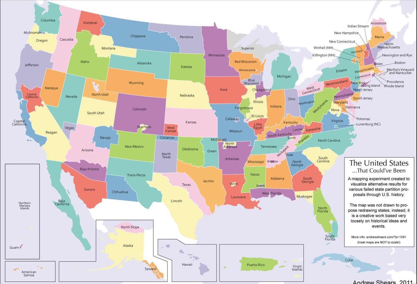
A map created by artist Andrew Shears, titled “The United States…That Could’ve Been,” shows a fascinating alternate reality with 124 different states. Instead of the 50 states we know, this map proposes a re-imagining of the U.S. based on various historical and political movements that never fully came to fruition.
A Look at Some of the Most Interesting States
The map is full of intriguing names and borders that tell a story. Here are a few that stand out:
- Cascadia: In the Pacific Northwest, the familiar states of Washington and Oregon are replaced by Cascadia and Columbia. The name Cascadia refers to a real-life secessionist movement that proposes forming an independent nation in this region, which is united by its geography and culture.
- Absaroka: This state, encompassing much of Wyoming and parts of Montana, is named after a proposed U.S. state from the 1930s. The name comes from the Crow Tribe, who are also known as the Apsáalooke or Absaroka. The idea of forming this state was a political protest against the New Deal policies.
- Trans-Pecos: This region of Texas, a remote and distinct area, is shown as its own state. There have been several historical attempts to separate it from the rest of Texas, often due to its unique geography and cultural identity.
- Deseret: The proposed state of Deseret, covering a massive area including Utah and parts of Nevada and Arizona, was an actual proposal by Mormon settlers in the mid-19th century. Although it never became a reality in its full form, the territory of Utah was eventually established, carving out a smaller portion of the originally planned state.
- Patomac and Little Egypt: The map also features a division of familiar states into smaller, more localized regions. For example, Virginia is split into several states, including Patomac and Little Egypt, which are based on regional identities and historical proposals.
Why Does This Map Exist?
The map isn’t a serious proposal for redrawing the United States. Instead, it’s a creative work that invites us to think about the contingent nature of history. It reminds us that the country’s borders and political divisions aren’t set in stone. The U.S. could have been a very different nation, and this map gives us a glimpse into those possibilities.
It’s a fun, thought-provoking way to explore American history and geography. So, which of these “could’ve been” states would you want to live in?